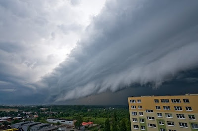
Asperatus is a rare, newly recognized cloud formation, that was proposed in 2009 as the first cloud formation added since cirrus intortus in 1951 to the International Cloud Atlas of the World Meteorological Organization. The name translates approximately as roughened or agitated waves.
Experts at the Royal Meteorological Society are now attempting to make it official by naming it 'Asperatus' after the Latin word for 'rough'.
The clouds are most closely related to undulatus clouds. Although they appear dark and storm-like, they tend to dissipate without a storm forming. The ominous-looking clouds have been particularly common in the Plains states of the United States, often during the morning or midday hours following convective thunderstorm activity. As of June, 2009 the Royal Meteorological Society is gathering evidence of the type of weather patterns in which undulus asperatus clouds appear, so as to study how they form and decide whether they are distinct from other undulatus clouds. Wikipedia.

Image Source


Monday, October 05, 2009
Asperatus: A New Cloud Type Discovered
Posted by
Fresh Pics
at
11:33 AM
![]()
Labels: Cool Pics, Nature, Paranormal, Weird Pics
Subscribe to:
Post Comments (Atom)


11 comments:
As like in the film,Highlander
I don't think this could be real. Perhaps it's made by Photoshop...
shun the nonbeliever
Mooooola!
The second picture is of Cedar Rapids, Iowa. I was living there the day those clouds passed over. It's not photoshop. People poured out of their houses and offices. Most of us expected aliens!
looks like most of these pics have been contrast-tweaked to high hell.
... and some were PS'ed:
http://news.nationalgeographic.com/news/2009/06/photogalleries/new-cloud-pictures/
Several of these photos are classical cumulus mammatus. Others are classical wave clouds. Those that appear unusual appear to be wave phenomena augmented by strong vertical ("thermal") activity. I live in the upper US midwest, and have seen most of these forms many times.
Many of the images have obviously had the contrast cranked up with Photoshop, but none appears to be invented.
Some pics are mammatus cloud type (which, BTW, have already been showed here!)
being born and raised in SWFL, Ive seen many of the various clouds in these pictures. that said, there are some that do look slightly different than the norm. while I will not disagree they may be a "newer" type of cloud, I sort of hope not as that would be more significant of a atmospheric change in effect, as I highly doubt that over the past few millennium no one has seen fit to document them :)
The Article says their rare clouds. I don't think so I'm seeing them often in the mid-west.
Post a Comment